Landmarks › Natural
Antelope Hills
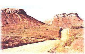
The distinctive formations of the Antelope Hills were a landmark for Spanish explorers in the 1500s and later for settlers moving west on the south branch of the California Road. This was a familiar landmark in early American history, once marking the international boundary line between the United States and Mexico.
Plan Your Visit
Getting There & Details
- Address
- 30 miles NW of Cheyenne
- Map
- Get Directions →
While You're in Cheyenne
More Things to Do
California Road Marker
Opened in the Spring of 1849, this road was first traveled by gold seekers in…
Learn more →Cheyenne City Park – Museums in the Park
The Cheyenne City Park contains seven museums, several memorial structures, playground equipment, a pavilion with…
Learn more →Battle of Washita Sculpture
Inside the Roger Mills County Courthouse in Cheyenne is a breathtaking, life size sculpture in…
Learn more →Black Kettle National Grassland
Black Kettle National Grassland covers about 32,000 acres in western Oklahoma and 2,000 acres in…
Learn more →Upcoming Events
Events in Cheyenne
Outdoors