Four Corner Survey Marker
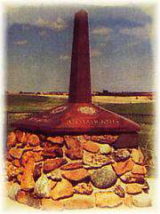
The Kansas-Nebraska Act of May 30, 1854, created the territories of Nebraska and Kansas, which had to be surveyed before settlement of the prairies could proceed. On May 8, 1855, Charles A. Manners set a cast-iron monument on the bluff west of the Missouri river at 40-degrees north latitude. In 1855-1856, Manners surveyed westward, from the cast iron monument 108 miles establishing the base-line, which is the boundary between Kansas and Nebraska and the Initial Point of the Sixth-Principal Meridian. This Initial Point, a red sandstone which lies under a manhole cover controls the system of sections, townships and ranges of the public land surveys in Nebraska, Kansas and parts of Colorado, Wyoming and South Dakota. This Initial Point is referenced in all ownership records throughout the system. On June 11, 1987, the Professional Surveyors of the Sixth-P.M. dedicated the memorial.
Getting There & Details
- Map
- Get Directions →
This historic marker is located one mile west and one mile north of Mahaska, Kansas.
More Things to Do
Campbell Bros. Circus -1885 to 1913
"Above the roar of the lions, the music of the calliope, and the laughter and…
Learn more →Bonham Theatre
Both the Bonham Theatre, and the First National Bank, located on the northwest corner of…
Learn more →Campbell Bros. Circus Mural
The Campbell Bros. Circus and other highlights of historic Fairbury are captured on this mural…
Learn more →“Wild Bill” Hickok…the Beginning
In the spring of 1859, Dave McCanles was on his way to the Colorado gold…
Learn more →