LASR.net Homepage


Menu


National Cemetery #2


category : Cemeteries
National Cemetery #2 
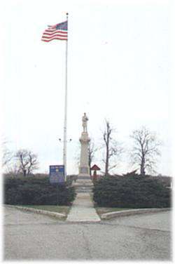
The soldier's plot in this cemetery was designated by the federal government after the Civil War on ground donated by the city for that purpose. It is under the jurisdiction of the National Cemetery Plot in Ft. Scott. The soldier's monument was erected in the spring of 1870 and the bodies of the victims of the attack on the fort and the massacre were reinterred in a common grave. Names of the 88 victims are engraved on the monument. The fence surrounding the plot is made of cannon barrels protruding from the ground. Originally, cannon balls were mounted on each barrel.


Address: 1 mile west of town on Hiway 166

Come visit us in Baxter Springs, Kansas

Attractions and Upcoming Events

Riverside Park

Riverside Park is located at the east edge of Baxter Springs on Spring River on the south side of Highway 166

Baxter Springs, KS Recreation

Black Dog Trail Marker

Located on the grounds of the Historical Museum, the marker commemorates the Black Dog Trail opened in 1803 by Chief Black Dog ( Manka - Chonka) and his band of Osage Indians who had a village nearby where springs once flowed freely.

Baxter Springs, KS Historical Markers

DAR Marker

Erected by the Baxter Springs Chapter of the DAR in 1931, the marker is dedicated in Memory of Gen. James G. Blunt and his escort who, defenseless fell victims to the inhuman ferocity of guerillas, led by the infamous Quantrill in his raid upon Baxter Springs, October 6, 1863, in which 135

Baxter Springs, KS Historical Markers

Historic Walking Tour

Walk along the downtown sidewalks on both sides of Military Avenue. Posted on the store fronts of the historic buildings are framed accounts of the original occupants of each store, their dates, and sometimes an account of a particular historical event that took place at that spot.

Baxter Springs, KS Tours

Tri-State Marker

See the Tri-State Marker and be in three states at once! The meeting point of Kansas, Oklahoma, and Missouri is 6 miles east of Baxter Springs on Highway 166/400. Turn south on the small paved road just west of the state line, and continue to the dead end. Built in 1938

Baxter Springs, KS Geographical Markers

Things to do Cemeteries near Baxter Springs, KS

Columbus Cemeteries

Columbus' cemeteries have records dating back to the 1800s....

Coffey County Cemeteries

The Coffey County Museum features a large genealogy library with cemetery listings, obituaries, all county newspapers from 18...

Teacher of the Plains Grave

Frank Hobbs was the first teacher in Elk County in 1869. In 1933, each student in the county contributed a nickel to build th...