LASR.net Homepage


Menu


Tri-State Marker


category : Geographical Markers
Tri-State Marker 
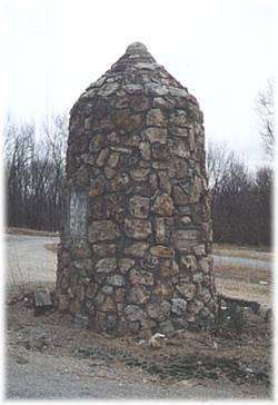
See the Tri-State Marker and be in three states at once! The meeting point of Kansas, Oklahoma, and Missouri is 6 miles east of Baxter Springs on Highway 166/400. Turn south on the small paved road just west of the state line, and continue to the dead end. Built in 1938 by the Youth Work Administration.


Come visit us in Baxter Springs, Kansas

Attractions and Upcoming Events

Civil War Tour

Take the self-guided Civil War tour of Baxter Springs. Visit 12 points of interest relating to the attack on Ft. Blair and the subsequent Battle of Baxter Springs. For example, SITE #2

Baxter Springs, KS Tours

Historic Bridges

* Rainbow Curve Bridge just north of town is the only remaining Marsh Arch bridge on Rt. 66. * The InterUrban Street Car Bridge spans the lazy banks of the Spring River.

Baxter Springs, KS Historic Bridges

Historic Walking Tour

Walk along the downtown sidewalks on both sides of Military Avenue. Posted on the store fronts of the historic buildings are framed accounts of the original occupants of each store, their dates, and sometimes an account of a particular historical event that took place at that spot.

Baxter Springs, KS Tours

Riverside Park

Riverside Park is located at the east edge of Baxter Springs on Spring River on the south side of Highway 166

Baxter Springs, KS Recreation

Fort Blair Site

Baxter Springs was a stopping place on the old Military Road serving Army forts which protected the preCivil War West from "hostile" Indians. It wasn't until 1862

Baxter Springs, KS Forts

Things to do Geographical Markers near Baxter Springs, KS