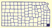
Cherokee County, KS
 Cherokee County is located in the territory that was part of the Louisiana Purchase in 1803. The area was then set out as the 'Neutral Lands" in a treaty with the Osage Indians in 1825. This 25 miles east- west by 50 miles north-south on the west of the Missouri border and east of the Osage Reservation was to be a buffer zone. Hunting, fishing, mineral extraction were allowed with no settlement of either white or Indians.
When the Cherokee Nation was relocated to the west from Georgia in 1835 they wanted more land. The Federal Government purchased from the Osage this 800,000 acres which then became known as the "Cherokee Neutral Lands".
The Kansas Territorial Legislature included the area in the setting of boundaries of the state in 1855. The southern boundary was to be at the 37th parallel and the area was named McGee County in 1860. Upon Kansas Statehood, January 29,1861, the area was 24 miles west by 50 miles north with the name changed to Cherokee County.
During the Civil War the Cherokee Indians sided with the south and believing they had ownership of the land, sold it to the Confederacy for $250,000 in Confederacy money, plus providing two companies of soldiers. This was to present a great deal of conflict over the title to the land.
Explore Cherokee County
Riverside Park
Riverside Park is located at the east edge of Baxter Springs on Spring River on the south side of Highway 166
Baxter Springs, KS RecreationLog Cabin
The log cabin was built east of the Lowell Cemetery in the 1870s. R.A. Hibbard built it as a home for his brother-in-law's family. Kent Lynch purchased the property and donated the cabin to the Historical Society in memory of Marsah Moncrief Lynch. In 1987
Baxter Springs, KS Pioneer HistoryBaxter Springs Historical Museum
The Baxter Springs Historical Museum is filled with exhibits depicting the various stages of the city'
Baxter Springs, KS Museums1919 Seth Thomas Clock
The clock was originally purchased through public donations as a war memorial for servicemen from Cherokee County who had served in World War 1. The giant Seth Thomas 1919 model clock was placed in the tower of the 1889 courthouse. In 1955
Columbus, KS ArtifactsDAR Marker
Erected by the Baxter Springs Chapter of the DAR in 1931, the marker is dedicated in Memory of Gen. James G. Blunt and his escort who, defenseless fell victims to the inhuman ferocity of guerillas, led by the infamous Quantrill in his raid upon Baxter Springs, October 6, 1863, in which 135
Baxter Springs, KS Historical MarkersHistoric Walking Tour
Walk along the downtown sidewalks on both sides of Military Avenue. Posted on the store fronts of the historic buildings are framed accounts of the original occupants of each store, their dates, and sometimes an account of a particular historical event that took place at that spot.
Baxter Springs, KS ToursMurals
1. " The Baxter Springs Massacre" by Edmond V. Ness is displayed inside the museum. - Historical Museum, 8th and East Avenue 2. Painted on the exterior wall of Bilke's Western Museum of the longhorn cattle drive. Artist, John Gibbons, 1991. - 11th and Military 3
Baxter Springs, KS ArtsColumbus' 1880s Town Square
Take a stroll around the 1880's square of Columbus and visit our shops. You must not miss the turn of the century architecture, or the unique color schemes of each building. Tour the community and see the many historical churches and Victorian homes. Driving tour map available at Chamber office, 320
Columbus, KS Historic DowntownsColumbus Wye and Frisco Caboose
The Columbus Wye is a one of its kind three way switch allowing trains to turn around. The crossing, formerly located in the northern part of Columbus was donated to the City of Columbus by the Burlington Northern Railroad. At the time the switch was constructed, it was one of the three built:
Columbus, KS Railroad HistoryBlack Dog Trail Marker
Located on the grounds of the Historical Museum, the marker commemorates the Black Dog Trail opened in 1803 by Chief Black Dog ( Manka - Chonka) and his band of Osage Indians who had a village nearby where springs once flowed freely.
Baxter Springs, KS Historical MarkersFort Blair Site
Baxter Springs was a stopping place on the old Military Road serving Army forts which protected the preCivil War West from "hostile" Indians. It wasn't until 1862
Baxter Springs, KS Forts