Black Mesa Archaeology

Black Mesa's history began millions of years ago when pre-historic beasts like the 65 foot-long brontosaurus, who skeleton was discovered here, roamed the area. Petrified logs, displayed in the park, are remnants of another era, also millions of years past. Primitive man entered the picture, according to scientific theory, some 10,000 to 12,000 years ago, and cliff dwellers are thought to have lived in the caves near Black Mesa 1500 to 2000 years ago.
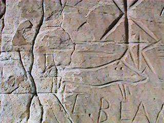
Coronado and his Spanish exploring expedition crossed the area. An inscription "Coronatto, 1541, " in old Castillian style and spelling, is carved upon a canyon wall. Its eroded condition upholds its authenticity.
The famed Santa Fe Trail crossed this corner of the Panhandle during its colorful 62 years of life, and over it passed wagon trains and thousands of travelers between Independence, Missouri and Santa Fe, New Mexico. The remains of old Fort Nicholas, established by Colonel Kit Carson for protection of travelers from hostile Indians, are still to be found southwest of the park area, near the New Mexico State line. The Panhandle became part of Oklahoma territory in 1890 and the State in 1907.
The fascinating past is revealed by Indian writings and pictographs. These crude writings and pictures show the daily life of the pre-Columbian Plains Indians and the animals they hunted.
Remnants of pumpkin vines and ears of corn support a theory that this was one of the earliest agricultural areas in the United States, cultivated during the time of Christ. Some experts believe the petrified logs found in abundance may be parent trees to the present giant Redwoods of California.
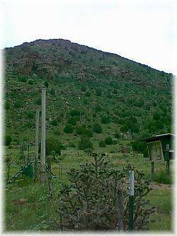
 Bird watchers, rock and fossil hounds, archaeology buffs, campers and anglers find common ground at Black Mesa named for a lava-topped mesa 8 miles north of Black Mesa State Park. At 4,973 feet, Black Mesa, formed 30 million years ago, is the highest point in Oklahoma and it extends for 45 miles into New Mexico and Colorado. The highest point can only be reached by a fairly challenging, 4 mile hiking trail and is marked by a granite monument. Around the park itself, travelers find dinosaur pits, American Indian pictographs and volcanic rock formations.
