
* Rainbow Curve Bridge just north of town is the only remaining Marsh Arch bridge on Rt. 66. * The InterUrban Street Car Bridge spans the lazy banks of the Spring River.
Baxter Springs, KS Historic BridgesThe soldier's plot in this cemetery was designated by the federal government after the Civil War on ground donated by the city for that purpose. It is under the jurisdiction of the National Cemetery Plot in Ft. Scott. The soldier's monument was erected in the spring of 1870
Baxter Springs, KS CemeteriesThis museum displays many awards and memorabilia of local sports heroes such as Mickey Mantle and Hale Irwin and other stars a Yogi Berra, Whitey Ford, Bill Russell, and other.
Baxter Springs, KS MuseumsThe Baxter Springs Historical Museum is filled with exhibits depicting the various stages of the city'
Baxter Springs, KS MuseumsTake the self-guided Civil War tour of Baxter Springs. Visit 12 points of interest relating to the attack on Ft. Blair and the subsequent Battle of Baxter Springs. For example, SITE #2
Baxter Springs, KS ToursCourse Access: PrivateHoles: 9Reserve Advance Tee Times: Yes...
The Chetopa Museum has many artifacts detailing the history of the town, newspaper microfilms, and genealogical research. ...
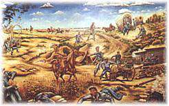 1. " The Baxter Springs Massacre" by Edmond V. Ness is displayed inside the museum. - Historical Museum, 8th and East Avenue
2. Painted on the exterior wall of Bilke's Western Museum of the longhor...
1. " The Baxter Springs Massacre" by Edmond V. Ness is displayed inside the museum. - Historical Museum, 8th and East Avenue
2. Painted on the exterior wall of Bilke's Western Museum of the longhor...