
Baxter Springs, Kansas
Historic Bridges
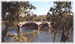 * Rainbow Curve Bridge just north of town is the only remaining Marsh Arch bridge on Rt. 66.
* The InterUrban Street Car Bridge spans the lazy banks of the Spring River.
...
* Rainbow Curve Bridge just north of town is the only remaining Marsh Arch bridge on Rt. 66.
* The InterUrban Street Car Bridge spans the lazy banks of the Spring River.
...
Historic Bridges
* Rainbow Curve Bridge just north of town is the only remaining Marsh Arch bridge on Rt. 66.
* The InterUrban Street Car Bridge spans the lazy banks of the Spring River.
... Located on the grounds of the Historical Museum, the marker commemorates the Black Dog Trail opened in 1803 by Chief Black Dog ( Manka - Chonka) and his band of Osage Indians who had a village nearby where springs once flowed freely.
Baxter Springs, KS Historical MarkersRiverside Park is located at the east edge of Baxter Springs on Spring River on the south side of Highway 166
Baxter Springs, KS RecreationThe log cabin was built east of the Lowell Cemetery in the 1870s. R.A. Hibbard built it as a home for his brother-in-law's family. Kent Lynch purchased the property and donated the cabin to the Historical Society in memory of Marsah Moncrief Lynch. In 1987
Baxter Springs, KS Pioneer HistorySee the Tri-State Marker and be in three states at once! The meeting point of Kansas, Oklahoma, and Missouri is 6 miles east of Baxter Springs on Highway 166/400. Turn south on the small paved road just west of the state line, and continue to the dead end. Built in 1938
Baxter Springs, KS Geographical MarkersErected by the Baxter Springs Chapter of the DAR in 1931, the marker is dedicated in Memory of Gen. James G. Blunt and his escort who, defenseless fell victims to the inhuman ferocity of guerillas, led by the infamous Quantrill in his raid upon Baxter Springs, October 6, 1863, in which 135
Baxter Springs, KS Historical MarkersWesleyan Church - In 1879 it was originally Presbyterian, then it became the FIRST Naza...