LASR.net Homepage


Menu

Sheridan, Arkansas

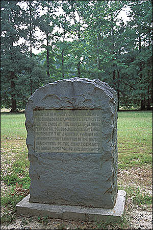
Directions: 13 miles south of Sheridan on the banks of the Saline River

General Steele's Federal troops were desperately trying to cross the river in flooded, foggy conditions when the Confederates began their attack. The battlefield, now largely in timber production, is still prone to heavy spring flooding, as it was when the two armies met there on April 30, 1864. It was the last major Arkansas battle in the Camden Expedition of the Red River Campaign. Picnic area.

Attractions and Upcoming Events

Things to do near Sheridan, AR

Old Rondo Cemetery

Directions: Near Rondo United Methodist Church The tiny town of Rondo became the repository of some state records in 1864 ...

Arkansas Museum of Natural Resources State Park

Credit Cards Accepted: MasterCard, Visa Food Service/Picnic Area Available Directions: Ark. 7 The museum collects, pr...

The Band Museum

Directions: Downtown Pine Bluff Only museum in America devoted to band instruments, the history of bands and band music. The...

Bradley County Veterans' Museum

For over 140 years, Bradley County's sons and daughters have served their country in times of peace and war. Their stories an...

Turner Neal Museum of Natural History

Museum of natural history of South Arkansas with three collections of big game; houses the Pomeroy Planetarium which seats 40...