Fort Gibson Dam
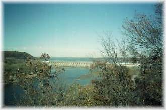
Surrounded by high bluffs, with the expansive lake on one side and rushing river on the other, the massive structure of Fort Gibson Dam is impressive. Observation areas provide excellent views. The dam is located on the Grand (or Neosho) river about five miles northwest of Fort Gibson and about eight miles above the point where the Grand river meets the Arkansas River. The lake lies in Wagoner, Cherokee and Mayes Counties, extending upriver to the Markham Ferry Dam.
Designed and built by the Tulsa District Corps of Engineers, the project was started in 1942, suspended during World War II, and completed in 1953.
Fort Gibson is the downstream unit of a three-lake system for flood control and hydroelectric power. Pensacola Dam on Grand Lake and Markham Ferry Dam on Lake Hudson are the other two units in the system. These three, together with Keystone Lake, Lake Eufaula and Lake Tenkiller store enough water to ensure year-round operation of the McClellan-Kerr Arkansas River Navigational System as well as serve the purposes of low-flow regulation and water supply.
Getting There & Details
- Address
- US Army Corps of EngineersP.O. Box 370Fort Gibson, OK 74434
- Phone
- 918-682-4314
- Map
- Get Directions →
More Things to Do
1903 Building
This interesting building is located on the corner of south Lee across from the Fort…
Learn more →First Presbyterian Church and Fort Gibson Bell
The bell located adjacent to the First Presbyterian Church was orginally used in the church…
Learn more →Cherokee National Cemetery
The Cherokee National Cemetery is a National Historic Landmark maintained by the Cherokee Nation from…
Learn more →Chouteau National Hiking Trail
The Jean Pierre Chouteau National Hiking Trail stretches from River Park to the Port of…
Learn more →