Fort Hays-Fort Dodge Road
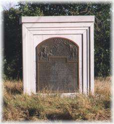
The Fort Hays-Fort Dodge Road is an interesting trail crossing the eastern part of Hodgeman County. The road was used to haul freight from the rail head to connect to the Santa Fe Trail, Fort Dodge and the New Mexico. The Duncan’s Crossing marker is found on the Pawnee Creek seven miles north and three miles east of Hanston. The original “cut” in the creek bank is visible today. Other ruts are visible three and one-half miles west of Hanston on US 156 just to the north. The Warner Ranch Sawlog Marker is located along the county line eleven miles south of Jetmore on US 283 and one and one-half miles east.
Getting There & Details
- Map
- Get Directions →
More Things to Do
Buckner Valley Park
Buckner Valley Park is located five and one-half miles west of Jetmore on Buckner Creek.…
Learn more →Hodgeman State Lake & Wildlife Area
Hodgeman State Lake & Wildlife Area is located 4 miles east of Jetmore on Highway…
Learn more →Jetmore City Lake
Jetmore City Lake, three miles west and one and one-half south of Jetmore, is located…
Learn more →Haun Museum
The Haun Museum is located in the first house on the townsite of Jetmore. Listed…
Learn more →